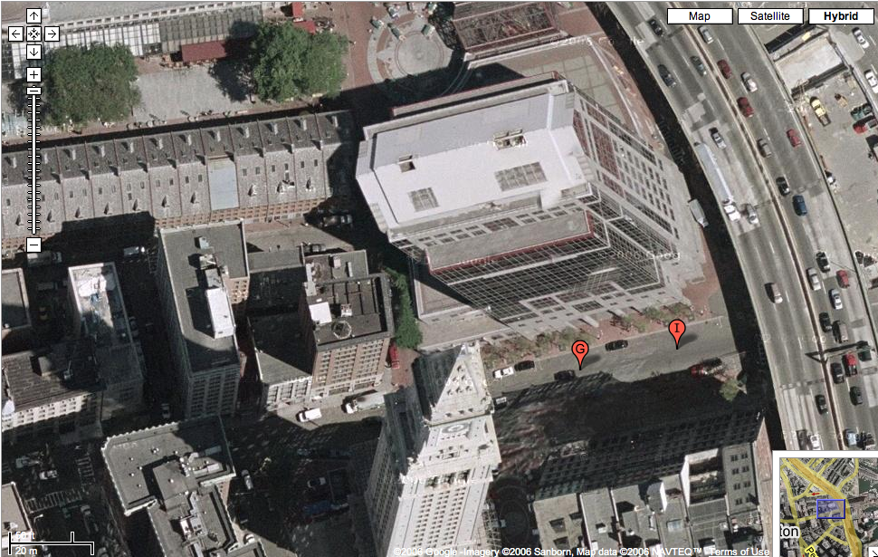
I was doing a little searching on Google Maps this evening and zoomed in on dowtown Boston. Check out the image I found of a part of downtown near Faneuil Hall. Doesn't it look like one of the buildings is falling over? I cannot figure this out. Why does this look so odd? It looks like a photo of one building was taken at a different angle and then plopped into this image. Anyone have an explanation?

6 comments:
I think it's the rendering software. You can see the building to the south suffers the same affliction; their positions more accurately reflect the road than the perspective.
G
Hmmm... how do you explain the ability to see the east and south sides of one building and the south and west sides the tower at the same time? I don't think it's rendering software unless what you mean is that the images on Google Maps are really a series of images taken at the exact same time but from different angles and compiled together. Is that the case?
I found the same thing when I was checking out NYC. It's really weird (and really cool!) and my little brain can't begin to understand it.
I don't even think they need to be taken at the exact same time. I think that since they are continually updating their satellite photos, they can mix and match to give the best possible view of the location you're pinpointing. You may also have hit the "overlap" in the photo, the end of one picture and the beginning of the next.
G
Dan, it's a feature of ortho photography. Ortho photography is the result of stretching an aerial photograph over top of a computer model of the earth's surface in that location. Without getting to techy, the only place on the ortho where buildings will appear straight up and down is at the nadir of the photo (the spot directly under the airplane when the image is taken). Features with a lot of distance from the earth's surface appear to "lean" away from the center of the image. These features are usually buildings, bridges, towers, and anything else that is tall. You see the same thing happen when you take multiple pictures to create a panorama. The edges of those photos don’t quite line up when put together and you can see the curvature of the earth when you lay those photos out side by side. There is new technology to create “true ortho” imagery, where all the buildings are in the correct location (i.e. without lean) by having the plane collect multiple, constant arrays of data instead of one picture at a time. Check out the new imagery in Google Earth of Philly and you’ll see what I’m talking about. None of the skyscrapers “lean” over the street.
This is something I use everyday with GIS (Geographic Information Systems). Next week is National Geography Week and GIS Day (yes, us map geeks have a GIS Day) is November 15th this year. Check out gisday.com for more info.
--tom rafferty
Tom - maybe I'm just really dense, but I still am not getting this. How can two buildings across the street from each other have such different vanishing points? I could understand if they were not very close to each other that this might happen (due to technical mapping reasons), but they are across the street from each other. Why does this not happen with the other buildings nearby?
Post a Comment